.png)


 Return
|
Ref ID: 1N2017/2777 | Posted On: 22-06-2017 | Updated on: 22-06-2017
|
|
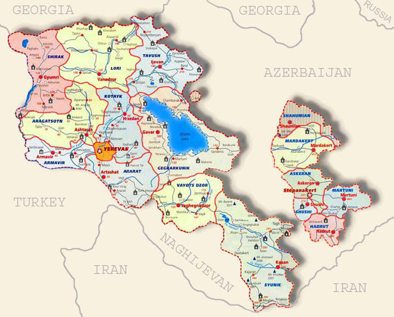
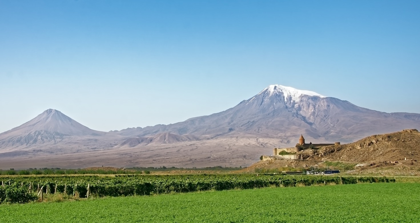
Administrative divisions of Armenia
Armenia is subdivided into eleven administrative divisions. Of these, ten are provinces, known as marzer (մարզեր) or in the singular form marz (մարզ) in Armenian.
Yerevan is treated separately and granted special administrative status as the country's capital. The chief executive in each of 10 marzer is the marzpet, appointed by the government of Armenia. In Yerevan, the chief executive is the mayor, appointed by the president.
First-level administrative entities
The following is a list of the regions with population, area, and density information.[1] Figures are from the National Statistical Service of the Republic of Armenia.[2] Note that the area of the Gegharkunik Province includes Lake Sevan which covers 1,278 square kilometres (493 sq mi) of its territory. To sort the information, use the arrow devices in the table headings.1) - Provinces
| Province | Population (2011 census) |
% | Population (2016 estimate) |
Area (km2) | Density | Urban communities |
Rural communities |
Capital |
|---|---|---|---|---|---|---|---|---|
| Aragatsotn Province | 132,925 | 4.4% | 129,800 | 2,756 | 48/km2 (120/sq mi) | 3 | 111 | |
| Ararat Province | 260,367 | 8.6% | 258,900 | 2,090 | 125/km2 (320/sq mi) | 4 | 93 | Artashat |
| Armavir Province | 265,770 | 8.8% | 266,600 | 1,242 | 214/km2 (550/sq mi) | 3 | 94 | |
| 235,075 | 7.8% | 231,800 | 5,349 | 44/km2 (110/sq mi) | 5 | 87 | ||
| 254,397 | 8.4% | 253,900 | 2,086 | 122/km2 (320/sq mi) | 7 | 60 | Hrazdan | |
| 235,537 | 7.8% | 225,000 | 3,799 | 62/km2 (160/sq mi) | 8 | 99 | ||
| Shirak Province | 251,941 | 8.3% | 243,200 | 2,680 | 94/km2 (240/sq mi) | 3 | 76 | |
| Syunik Province | 141,771 | 4.7% | 139,400 | 4,506 | 32/km2 (83/sq mi) | 6 | 66 | |
| Tavush Province | 128,609 | 4.3% | 125,500 | 2,704 | 48/km2 (120/sq mi) | 5 | 35 | |
| Vayots Dzor Province | 52,324 | 1.7% | 50,800 | 2,308 | 23/km2 (60/sq mi) | 3 | 26 | Yeghegnadzor |
| 1,060,138 | 35.1% | 1,073,700 | 223 | 4,754/km2 (12,310/sq mi) | 1 | n/a | n/a |
2) - List of Provinces and main cities in Armeny
| Rank | City | In Armenian | Province | Founded | Population census (2011) | Population estimate (2016) | Area (km2) | Distance from Yerevan (kms) |
| 1 | Yerevan | Երևան | N/A | 782 BC | 1,060,138 | 1,073,700 | 223 | |
| 2 | Gyumri | Գյումրի | Shirak | 5th century BC as Kumayri, 1837 as Alexandropol | 121.976 | 65.7 | 54 | 126 |
| 3 | Vanadzor | Վանաձոր | Lori | 1828 | 86.199 | 45.2 | 32 | 125 |
| 4 | Vagharshapat (Etchmiadzin) | Վաղարշապատ (Էջմիածին) | Armavir | 685 BC | 46.54 | 37.7 | 13 | 20 |
| 5 | Abovyan | Աբովյան | Kotayk | 1963 | 43.495 | 35.4 | 11 | 11 |
| 6 | Kapan | Կապան | Syunik | 10th century | 43.19 | 34.6 | 36 | 320 |
| 7 | Hrazdan | Հրազդան | Kotayk | 1959 | 41.875 | 32.2 | 22 | 50 |
| 8 | Armavir | Արմավիր | Armavir | 1931 | 29.319 | 25.9 | 8.51 | 48 |
| 9 | Artashat | Արտաշատ | Ararat | 1945 | 22.269 | 18.7 | 12 | 30 |
| 10 | Charentsavan | Չարենցավան | Kotayk | 1948 | 20.363 | 20.363 | 5 | 38 |
| 11 | Masis | Մասիս | Ararat | 1953 | 20.215 | 18.5 | 5.7 | 20 |
| 12 | Ararat | Արարատ | Ararat | 1930 | 20.235 | 18.3 | 6 | 60 |
| 13 | Ijevan | Իջևան | Tavush | 1780s | 21.081 | 17.7 | 4.6 | 142 |
| 14 | Gavar | Գավառ | Gegharkunik | 1830 | 20.765 | 17.5 | 16 | |
| 15 | Sevan | Սևան | Gegharkunik | 1842 | 19.229 | 17.2 | 17.75 | 66 |
| 16 | Ashtarak | Աշտարակ | Aragatsotn | 9th century | 18.834 | 17 | 7.5 | 22 |
| 18 | Artik | Արթիկ | Shirak | 1939 | 19.534 | 16.8 | 9 | 105 |
| 19 | Dilijan | Դիլիջան | Tavush | 1544 | 17.712 | 16.6 | 13 | 100 |
| 20 | Goris | Գորիս | Syunik | 1870 | 20.591 | 16.3 | 8 | 250 |
| 21 | Sisian | Սիսիան | Syunik | 8th century BC | 14.894 | 12.9 | 9 | 217 |
| 22 | Vardenis | Վարդենիս | Gegharkunik | 1830 | 12.685 | 11.6 | 10 | 168 |
| 23 | Martuni | Մարտունի | Gegharkunik | 1830 | 12.894 | 11.2 | 10 | 130 |
| 24 | Alaverdi | Ալավերդի | Lori | 1899 | 13.343 | 11 | 18 | 191 |
| 25 | Spitak | Սպիտակ | Lori | 17th century | 12.881 | 11 | 5.6 | 101 |
| 26 | Yeghvard | Եղվարդ | Kotayk | 6th century (first mentioned) | 11.672 | 10.9 | 7 | 30 |
| 27 | Stepanavan | Ստեփանավան | Lori | 1810 | 13.086 | 10.8 | 14 | 157 |
| 28 | Vedi | Վեդի | Ararat | 13th century (first mentioned) | 11.384 | 10.6 | 5.6 | 49 |
| 29 | Nor Hachn | Նոր Հաճն | Kotayk | 1953 | 9.307 | 8.4 | 2.3 | 24 |
| 30 | Byureghavan | Բյուրեղավան | Kotayk | 1945 | 9.51 | 8.30 | 4 | 25 |
| 31 | Metsamor | Մեծամոր | Armavir | 1969 | 9.19 | 8 | 4 | 35 |
| 32 | Berd | Բերդ | Tavush | 10th century | 7.957 | 6.7 | 3.5 | 211 |
| 33 | Yeghegnadzor | Եղեգնաձոր | Vayots Dzor | 5th century (first mentioned) | 7.944 | 6.6 | 6 | 122 |
| 34 | Tashir | Տաշիր | Lori | 1844 | 7.773 | 6.5 | 5.6 | 174 |
| 35 | Kajaran | Քաջարան | Syunik | 1958 | 7.163 | 6.1 | 2.8 | 385 |
| 36 | oshakan | Օշական | Aragatsotn | 5.822 | 27 | |||
| 37 | Aparan | Ապարան | Aragatsotn | 2nd century (first mentioned) | 6.451 | 5.3 | 3.5 | 59 |
| 38 | Chambarak | Ճամբարակ | Gegharkunik | 1830s | 5.85 | 4.7 | 6 | 125 |
| 39 | Vayk | Վայք | Vayots Dzor | 1828 | 5.877 | 4.7 | 3 | 139 |
| 40 | Maralik | Մարալիկ | Shirak | 5th century (first mentioned) | 5.398 | 4.5 | 4 | 105 |
| 41 | Martakert | Մարտակերտ | 4.5 | 300 | ||||
| 42 | Noyemberyan | Նոյեմբերյան | Tavush | 13th century (first settled) | 5.31 | 3.9 | 3.6 | 191 |
| 43 | Talin | Թալին | Aragatsotn | 2nd century (first mentioned) | 5.31 | 3.8 | 7 | 74 |
| 44 | Meghri | Մեղրի | Syunik | 17th century | 4.58 | 3.5 | 3 | 393 |
| 45 | Jermuk | Ջերմուկ | Vayots Dzor | 13th century (first mentioned) | 4.628 | 3.4 | 5 | 178 |
| 46 | Ashotsk | Աշոցք | Shirak | 2.482 | 157 | |||
| 47 | Ohanavan | Օհանավան | Aragatsotn | 2.414 | 28 | |||
| 48 | Ayrum | Այրում | Tavush | 1937 | 2.126 | 1.4 | 1.6 | 206 |
| 49 | Akhtala | Ախթալա | Lori | 18th century (first mentioned) | 2.092 | 1.3 | 4.3 | 186 |
| 50 | Tumanyan | Թումանյան | Lori | 1926 | 1.71 | 1 | 1 | 149 |
| 51 | Tsaghkadzor | Ծաղկաձոր | Kotayk | 3rd century (first mentioned) | 1.256 | 0.9 | 4 | 79 |
| 52 | Artashavan | Արտաշավան | Aragatsotn | 0.624 | 32 | |||
| 53 | Shamlugh | Շամլուղ | Lori | 1770 | 700 | 0.5 | 3.6 | 196 |
| 54 | Geghard | Գեղարդ | Kotayk | 0.47 | 40 | |||
| 55 | Dastakert | Դաստակերտ | Syunik | 12th century (first mentioned) | 323 | 0.25 | 0.5 | 236 |
| 56 | Stepanakert | Ստեփանակերտ | 330 |
Communities (hamaynkner)
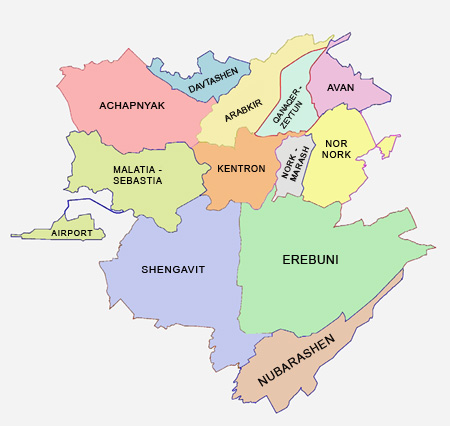
Within each province are communities (hamaynkner, singular hamaynk). Each community is self-governing and consists of one or more settlements (bnakavayrer, singular bnakavayr). Settlements are classified as either towns (kaghakner, singular kaghak) or villages (gyugher, singular gyugh). As of June 2017, Armenia is divided into 795 communities, of which 48 are considered urban and 747 are considered rural. The capital, Yerevan, also holds the status of a community.[3] Additionally, Yerevan is divided into twelve semi-autonomous districts.
Terminology
| Armenian singular | Armenian plural | English | Comment |
|---|---|---|---|
| marz (մարզ) | marzer (մարզեր) | province | First-level |
| hamaynk (համայնք) | hamaynkner (համայնքներ) | community, either urban (city/town) or rural (village) | Second-level |
| bnakavayr | bnakavayrer | settlement (village) | Third-level |
| t'aghayin hamaynk (թաղային համայնք) | t'aghayin hamaynkner (թաղային համայնքներ) | neighborhood community or district | only in Yerevan, see Districts of Yerevan |
3) - Districts of Yerevan
Yerevan is divided into twelve "administrative districts" (վարչական շրջաններ), each with an elected community leader. Each district is divided into unofficial neighborhoods (թաղամասեր or թաղեր). The total area of the 12 districts of Yerevan is 223 square kilometres (86 square miles).
| District | Armenian | Population (2011 census) |
Population (2016 estimate) |
Area (km²) |
|---|---|---|---|---|
| Ajapnyak | Աջափնյակ | 108,282 | 109,100 | 25.82 |
| Arabkir | Արաբկիր | 117,704 | 115,800 | 13.29 |
| Avan | Ավան | 53,231 | 53,100 | 7.26 |
| Davtashen | Դավթաշեն | 42,380 | 42,500 | 6.47 |
| Erebuni | Էրեբունի | 123,092 | 126,500 | 47.49 |
| Kanaker-Zeytun | Քանաքեր-Զեյթուն | 73,886 | 74,100 | 7.73 |
| Kentron | Կենտրոն | 125,453 | 125,700 | 13.35 |
| Malatia-Sebastia | Մալաթիա-Սեբաստիա | 132,900 | 135,900 | 25.16 |
| Nork-Marash | Նորք-Մարաշ | 12,049 | 11,800 | 4.76 |
| Nor Nork | Նոր Նորք | 126,065 | 130,300 | 14.11 |
| Nubarashen | Նուբարաշեն | 9,561 | 9,800 | 17.24 |
| Shengavit | Շենգավիթ | 135,535 | 139,100 | 40.6 |

The twelve districts of Yerevan
source : https://en.wikipedia.org/wiki/Districts_of_Yerevan